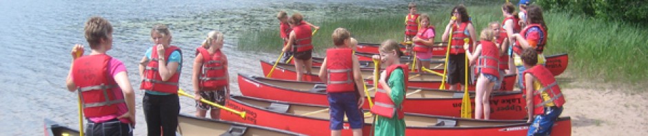
St. Croix River Water Trail
Information Downloads (require Adobe Reader)
St Croix River Water Trail Journey
St Croix River Water Trail Map 5-19-08
St Croix River Water Trail Suggestions and Safety Tips
Click on image to enlarge.
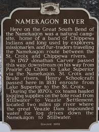
Imagine that you are in a canoe with Henry Schoolcraft paddling at the headwaters of the St. Croix River in 1832. You are on a route traveled 65 years earlier by English explorers, 150 years earlier by French explorers, and blazed hundreds of years earlier by local Ojibwe. One can imagine this quite clearly, as Schoolcraft’s journals are still available to us today.
This is an area with tall pines and clear waters. Traveling from Solon Springs the source of the St. Croix River, southward to Gordon, you paddle through stands of wild rice, seeing loons, herons, ospreys, deer, and an occasional black bear. Eagles and river otters escort you along your journey. In early August just after sunset, you can sometimes get the young wolves from the wolf pack to respond to your howls. This is an extraordinary experience.
Even more extraordinary, you can still have this experience today.
The water trail goes from the north end of Upper St. Croix Lake, south past Crownhart Island, across the source of the St. Croix River at the south end of the lake, down a six-mile reach of the upper St. Croix River, and across the St. Croix Flowage to west end where the St. Croix National Scenic Riverway starts.
A small stream at the north end of Upper St. Croix Lake, St. Croix Creek, marks the southern end of the famous Brule- St. Croix Portage trail. This portage enabled early travelers to go up the Brule River from Lake Superior, carry their canoes along this portage across the divide, and then go down the St. Croix River to the Mississippi River at Prescott.
The historical map above was drawn by U.S. Army Lt. James Allen as he followed the path of the English, French and Chippewa as they traveled these waters starting sometime in the 1500’s.
The extract below is Lt. Allen’s journal entry of August 4, 1832 as he reached the St. Croix Flowage at Gordon. He is now several days behind explorer Henry Schoolcraft, whom he was ordered to accompany. Note: the St. Croix Flowage was historically called Whitefish Lake and Lower Ox Creek was called Ox River.
August 4, 1832. Passed a long expansion of the river [Whitefish Lake], grown over with wild rice, on the east side of which is an Indian village, of seven or eight lodges, with gardens of potatoes, squashes, and corn, adjacent. This is Keppemeppas permanent village; but all the Indians were now absent, hunting or fishing. Twelve or fifteen miles above this village, we came to another expansion, or narrow rice lake, five or six miles long, the upper end of which receives the Ox river; the St. Croix coming in below the Ox river, on the west side. From my ignorance of the route, I was near getting lost at this place, by following up the wrong river. A broad, plain channel, with a current all the way, leads up, through the rice, to the mouth of Ox river; but the St. Croix, which is here the smaller of the two rivers, comes in, as it were, on one side of the rice pond, and has its mouth, in a measure, concealed by the grass growing in it. Each canoe passed in succession to the mouth of the former river, without noticing the latter; but I had remarked, as I passed, an opening in the woods, as though a stream came in; and after entering the mouth of the wrong river, I went back, to be satisfied as to this appearance, and found the stream; but, from its being smaller than the other, I was still in doubt which to take, till I had followed it up a short distance, to a rapid, where I observed, on a rock in the bottom, a little red spot, which, on examination, proved to be red lead paint rubbed from Mr. S.’s canoe, which had touched the rock. This little circumstance determined this to be the proper route, and save me from the error of taking the other; which, if I had done, might have led to further error, and been attended with serious consequences: for, if I had been lost for many days in this poor country, till my provisions were exhausted, starvation would have been almost inevitable.
From here the St. Croix, now very small, crooked a few miles through a tamarack and cedar swamp, and brought us to its source, in a beautiful, clear, deep lake, (Upper Lake St. Croix,) twelve miles long, and from one to three miles wide, with a pretty little island near its southern end, on which were two Indian lodges, but no Indians.